Day 1 Log for March 27, 2005 - Going to Colorado & Getting Camper

Day 1: Sterling, VA - Greenville, IL
We took a picture of me in the car with the computer. Sasha and I got on the road at 10:45 am (almost two hours after our stated time for 9 am leaving) and I set up the GPS system on the computer and started trying to figure out our route- first it stated that we were going to Chicago, and then it was give us back routes.  Ultimately, I will figure out how to use this program while on the road. There is slight drizzle as we are going through the Loudoun County countryside, taking Rt. 15 over the bridge on the way
 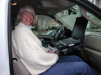 towards Frederick. Internet had Full bars Very bouncy road before the bridge.
In Maryland, saw a train while we were going over the Potomac River. Only two bars for internet in MD.
We just got onto Rt. 340 in MD not drizzling now. Exterior temperature is 47 F.
Just got on I-70 at 11:30 am, this is the road we will be on for most of the trip. Four bars as we are going through the hills of MD.
Just past Braddock Mountain 985 feet Above Sea Level (ASL) and our ears just popped.
Already I have to make a pit-stop, the caffeine I had this morning is making itself known. 11:40 gas prices: 2.11 for regular, 2.34 for diesel (what the truck takes.)
There seems to be a few more cars on the road than what we thought…People going to where they need or taking vacations like us? Who knows? But we are still moving at a good clip of 70 mph.
Just powered down and then turned the computer back on, the internet was not working, I believe, because of intense shaking when we were going over a bumpy patch. Working ok now, we are at an area where there is a red bar, means very slow connection. Slightly more drizzle-more like light rain. Now rain. Now a bit of fog and rain which makes this hard Sliding Hill with elevation of 1249 feet, ASL.
Saw a covered bridge going along Route 68.
Haystack Mountain 1240 feet ASL no internet service, had some problems with GPS and internet before this. Raining and my ears are popping again. Internet service goes in and out. Foggy again.
No more fog @1:20pm but it was slow going for a while there.
Back to fog again.
Out of fog again.
Woo Hoo, in West Virginia at 1:35 pm elevation 2381 ft. ASL, no rain actually sunny.
Raining again as we go onto I-79 to I-70. Elevation 1025 going over a river.
Woo hoo; we are now in Pennsylvania, 2:11 pm, going up in elevation, raining again.
Back on I-70 again at 2:40 pm slight rain and around 50 F outside. A few bars now.
We are now in West Virginia again for a short time, at 2:57 with rain, and elevation of 1330. We just checked online to find out what the diesel prices were in Flying J in Kirkersville, OH. $2.19 which is not bad, full bars for internet.
We are now in OH having gotten here at 3:09 pm with the rain, 815 ft elevation and on Rt. 470 going around Wheeling.
Back on 70
Making stop at Flying J to get diesel $77.33 35.15 gals 2.20 a gallon engine hours 92.8 mileage 3341.
http://www.greenvilleusa.org/events.htm to find hotels
Back on the road 5:35 pm spitting rain as we are going to Columbus OH; we are discussing whether to be at a super 8 or a best western, based on which one has a kitchen.
Looked at my cell phone and I have no service for the phone but do have service for the internet with T-Mobile. Interesting.
Just saw a sign for MI Homes-looks like they are building out here. MI Homes was the company that made our home and we don’t really see them in Virginia area anymore. Our guess is that it got too expensive to build out by us.
Seeing lots of farms and relatively flat land, we are at an elevation of 955 feet ASL. Sasha is happy, he hit 15 mpg on the truck, probably because he has the cruise control on. But this is pretty cool for a big truck. For some reason, I still do not have service with my phone. And we are almost in Indiana. What is it with Cingular?
We are out of Ohio and in Indiana, at 7:11 pm with no rain just cloudy, elevation at 1100 feet ASL, and an exterior temperature of 43 F.
It is very dark out here, can’t really see very much but the elevation is roughly the same as Ohio, at 960 but then it started to go up, to 1050 feet ASL. Yea! My phone is working again, strange service company but I am recharging it now.
Stopped and got dinner before we got into Indianapolis, went to Wendy’s 8 pm.
In downtown area of Indianapolis 8:40 - I keep wanting to say Annapolis!
We are out of Indianapolis now, trying to look for hotels close to St. Louis.
Yahoo, we are now in Illinois @ 9:43 pm, cloudy skies I guess, as it is dark and no stars visible. The elevation is 590 feet ASL; we just watched as a 18 wheeler and a SUV fought each other over a lane change, the 18-er was trying to move over to the right lane from the left lane and the SUV would not let him in the lane. Then the 18 wheeler passed another truck and then GOT off the highway speeding. Where are the cops when you need them to pull over the stupid people?
Oh, and the exterior temp is 44 F.
We are going to stay at Greenville, IL Best Western. It will be interesting to go to a Best Western; I have not been to one in years!
The road is very smooth here, I can type and there is hardly any bouncing. There still are a bunch of people on the road at this time of night.
Huge Cross on the side of the road and has lights on it or is lit? At exit 158 on I-70 in Illinois.
Day 1.5 (Night) stayed at a Best Western in Greenville, IL. The hotel was nice for $60 with a refrigerator. The shower is OK, but nice hot water and made for tall people. No stooping here. The beds were very comfy and they had free high speed internet access! Hilton and Marriott take note: Best Western free internet service is a great idea.
 Ultimately, I will figure out how to use this program while on the road. There is slight drizzle as we are going through the Loudoun County countryside, taking Rt. 15 over the bridge on the way
  towards Frederick. Internet had Full bars Very bouncy road before the bridge.
In Maryland, saw a train while we were going over the Potomac River. Only two bars for internet in MD.
We just got onto Rt. 340 in MD not drizzling now. Exterior temperature is 47 F.
Just got on I-70 at 11:30 am, this is the road we will be on for most of the trip. Four bars as we are going through the hills of MD.
Just past Braddock Mountain 985 feet Above Sea Level (ASL) and our ears just popped.
Already I have to make a pit-stop, the caffeine I had this morning is making itself known. 11:40 gas prices: 2.11 for regular, 2.34 for diesel (what the truck takes.)
There seems to be a few more cars on the road than what we thought…People going to where they need or taking vacations like us? Who knows? But we are still moving at a good clip of 70 mph.
Just powered down and then turned the computer back on, the internet was not working, I believe, because of intense shaking when we were going over a bumpy patch. Working ok now, we are at an area where there is a red bar, means very slow connection. Slightly more drizzle-more like light rain. Now rain. Now a bit of fog and rain which makes this hard Sliding Hill with elevation of 1249 feet, ASL.
Saw a covered bridge going along Route 68.
Haystack Mountain 1240 feet ASL no internet service, had some problems with GPS and internet before this. Raining and my ears are popping again. Internet service goes in and out. Foggy again.
No more fog @1:20pm but it was slow going for a while there.
Back to fog again.
Out of fog again.
Woo Hoo, in West Virginia at 1:35 pm elevation 2381 ft. ASL, no rain actually sunny.
Raining again as we go onto I-79 to I-70. Elevation 1025 going over a river.
Woo hoo; we are now in Pennsylvania, 2:11 pm, going up in elevation, raining again.
Back on I-70 again at 2:40 pm slight rain and around 50 F outside. A few bars now.
We are now in West Virginia again for a short time, at 2:57 with rain, and elevation of 1330. We just checked online to find out what the diesel prices were in Flying J in Kirkersville, OH. $2.19 which is not bad, full bars for internet.
We are now in OH having gotten here at 3:09 pm with the rain, 815 ft elevation and on Rt. 470 going around Wheeling.
Back on 70
Making stop at Flying J to get diesel $77.33 35.15 gals 2.20 a gallon engine hours 92.8 mileage 3341.
http://www.greenvilleusa.org/events.htm to find hotels
Back on the road 5:35 pm spitting rain as we are going to Columbus OH; we are discussing whether to be at a super 8 or a best western, based on which one has a kitchen.
Looked at my cell phone and I have no service for the phone but do have service for the internet with T-Mobile. Interesting.
Just saw a sign for MI Homes-looks like they are building out here. MI Homes was the company that made our home and we don’t really see them in Virginia area anymore. Our guess is that it got too expensive to build out by us.
Seeing lots of farms and relatively flat land, we are at an elevation of 955 feet ASL. Sasha is happy, he hit 15 mpg on the truck, probably because he has the cruise control on. But this is pretty cool for a big truck. For some reason, I still do not have service with my phone. And we are almost in Indiana. What is it with Cingular?
We are out of Ohio and in Indiana, at 7:11 pm with no rain just cloudy, elevation at 1100 feet ASL, and an exterior temperature of 43 F.
It is very dark out here, can’t really see very much but the elevation is roughly the same as Ohio, at 960 but then it started to go up, to 1050 feet ASL. Yea! My phone is working again, strange service company but I am recharging it now.
Stopped and got dinner before we got into Indianapolis, went to Wendy’s 8 pm.
In downtown area of Indianapolis 8:40 - I keep wanting to say Annapolis!

We are out of Indianapolis now, trying to look for hotels close to St. Louis.
Yahoo, we are now in Illinois @ 9:43 pm, cloudy skies I guess, as it is dark and no stars visible. The elevation is 590 feet ASL; we just watched as a 18 wheeler and a SUV fought each other over a lane change, the 18-er was trying to move over to the right lane from the left lane and the SUV would not let him in the lane. Then the 18 wheeler passed another truck and then GOT off the highway speeding. Where are the cops when you need them to pull over the stupid people?
Oh, and the exterior temp is 44 F.
We are going to stay at Greenville, IL Best Western. It will be interesting to go to a Best Western; I have not been to one in years!
The road is very smooth here, I can type and there is hardly any bouncing. There still are a bunch of people on the road at this time of night.
Huge Cross on the side of the road and has lights on it or is lit? At exit 158 on I-70 in Illinois.
Day 1.5 (Night) stayed at a Best Western in Greenville, IL. The hotel was nice for $60 with a refrigerator. The shower is OK, but nice hot water and made for tall people. No stooping here. The beds were very comfy and they had free high speed internet access! Hilton and Marriott take note: Best Western free internet service is a great idea.
posted by Laura-n-Sasha at 12:13 PM
![]()
![]()


3 Comments:
تاتش
عزل خزانات الشارقة
عزل مسابح بالشارقة
This comment has been removed by the author.
النجم
وتر بروف بدبى
تركيب كربستون دبى
Post a Comment
<< Home